Wondering what neighborhood you live in? Click here to view a map of all the community neighborhoods.
Want to stay up-to-date with neighborhood happenings? Sign-up for Nextdoor.
The boundaries of the Gateway Neighborhood Association are N. 8th Street to North 14th Street and Erie Avenue to Superior Avenue. Gateway became the first official Neighborhood Association on December 20, 2010.
Click here to view a map of the neighborhood
Click here to view more information about the neighborhood
See calendar for meeting dates and events
Neighborhood Contact:
Keith Jacks, President
keithjacks@hotmail.com
The boundaries of the Ellis Historic Neighborhood Association are the lake to N. 7th Street and Pennsylvania Avenue to Ontario Avenue. Ellis Historic became the 2nd official Neighborhood Association in October 2011.
Click here to view a map of the neighborhood
See calendar for meeting dates and events
Neighborhood Contact:
Jon Dolson, President
mail@jondolson.com
(Formerly called North Flats)
The boundaries of Maple Heights Neighborhood Association are N. 12th Street to N. 8th Street and Superior Avenue to Geele Avenue. Maple Heights was recognized by the Common Council as the 3rd official Neighborhood Association on November 3, 2014.
Click here to view a map of the neighborhood
See calendar for meeting dates and events
Neighborhood Contact:
Brenda Goddard, Secretary/Treasurer
bjgoddard59@gmail.com
The boundaries of the Near North Neighbors Association are the lake to North 8th Street and Erie Avenue to Superior Avenue. Near North was recognized by the Common Council as the 4th official Neighborhood Association on March 21, 2016.
Click here to view a map of the neighborhood
Click here for the neighborhood’s Facebook page
See calendar for meeting dates and events
Neighborhood Contact:
Jenny Holm, President
tcuswan3@yahoo.com
The boundaries of the Indiana Corridor Neighborhood Association are S. 14th Street to the city limits on the west and Indiana Avenue to Georgia Avenue. The Indiana Corridor Neighborhood Association was recognized by the Common Council as the 5th official Neighborhood Association on June 20, 2016.
Click here to view a map of the neighborhood
Click here for the neighborhood’s Facebook page
See calendar for meeting dates and events
Neighborhood Contact:
Pete Sjollema, President
peteandshellysjollema@yahoo.com
The boundaries of the King Park Neighborhood are the lake to S. 9th Street and Broadway Avenue to Indiana Avenue. King Park was recognized by the Common Council as the 6th official Neighborhood Association on September 5, 2017.
Click here to view a map of the neighborhood
See calendar for meeting dates and events
Click here for the neighborhood’s Facebook page
Neighborhood Contact:
Rick Behnke, Treasurer
behnksta1@aol.com
The boundaries of the Memorial Neighborhood are the lake to N. 8th Street and Geele Avenue to North Avenue. Memorial was recognized by the Common Council as the 7th official Neighborhood Association on November 6, 2017.
Click here to view a map of the neighborhood
See calendar for meeting dates and events
Neighborhood Contact:
Jody Kraemer, President
memorialneighborhoodsheboygan@gmail.com
The boundaries of the Vollrath/North Point Neighborhood the south side of Geele Avenue on the north between N. 3rd and N. 4th Streets and then extending to the lake, north side of Superior Avenue on the south from N. 4th Street to the lake, N. 4th Street on the west from Geele Avenue to Superior Avenue, and the lake on the east from Geele Avenue to Superior Avenue. Vollrath/North Point was recognized by the Common Council as the 8th official Neighborhood Association on August 6, 2018.
Click here to view a map of the neighborhood
See calendar for meeting dates and events
Click here for the neighborhood’s Facebook page
Neighborhood Contact:
Beth Counard, President
jcounard2@charter.net
Historic Grant
(Formerly called East Side)
The boundaries of Historic Grant Neighborhood Association are the south side of Geele Avenue on the north between N. 4th and N. 8th Streets, north side of Superior Avenue on the south between N. 4th and N. 8th Streets, east wide of N. 8th Street on the west from Geele Avenue to Superior Avenue, and on the west side of N. 4th Street on the east from Geele Avenue to Superior Avenue. Historic Grant was recognized by the Common Council as the 9th official Neighborhood Association on September 17, 2018.
Click Here to view a map of the neighborhood
See calendar for meeting dates and events
Click here for the neighborhood’s Facebook page
Neighborhood Contact:
Abby Ries, President
glyna4477@gmail.com
The boundaries of the End Park Neighborhood Association are the north side of Geele Avenue to the south side of North Avenue, between the west side of N. 8th Street and the east side of N. 13th Street. End Park was recognized by the Common Council as the 10th official Neighborhood Association on August 5, 2019.
Click here to view a map of the neighborhood
See calendar for meeting dates and events
Neighborhood Contact:
Cleo Messner
cleosellshomes@gmail.com
The boundaries of the Kuehne Park Neighborhood Association are the north side of Superior Avenue to the south side of Geele Avenue between the west side of N. 12th Street to the east side of the Union Pacific Railroad tracks. Kuehne Park was recognized by the Common Council as the 11th official Neighborhood Association on October 19, 2020.
Click here for a map of the neighborhood
See calendar for meeting dates and events
Neighborhood contact:
Abby Block
abbyeblockcnp@gmail.com
The boundaries of the Franklin Park Neighborhood are from the east side of S. 14th Street to the west side of S. 9th Street between the north side of Broadway Avenue to the south side of Indiana Avenue plus the north side of Indiana Avenue from S. 9th Street west to the property of 1218 Indiana Avenue. When the Franklin Park Neighborhood Association was formed, it extended its boundaries to the north and included what was then The Flats Neighborhood. Anyone living in the area from the north side of Georgia Avenue to the south and north sides of Indiana Avenue (excluding the north side of Indiana Avenue from S. 13th to S. 14th Street) between the east side of S. 14th Street to the west side of S. 9th Street, are now part of the Franklin Park Neighborhood Association. The Flats Neighborhood has been absorbed by the Franklin Park Neighborhood Association and no longer exists. Franklin Park was recognized by the Common Council as the 12th official Neighborhood Association on November 16, 2020.
Click here for a map of the neighborhood
See calendar for meeting dates and events
Neighborhood contact:
Edward Procek
edward.procek@sheboygancounty.com
The boundaries of the James Madison – Veterans Park Neighborhood Association are the west side of the Union Pacific railroad tracks to the east side of S. 24th Street, between the north side of Union Avenue to the south side of Georgia Avenue. James Madison Neighborhood was recognized by the Common Council as the 13th official Neighborhood Association on April 6, 2022 and was subsequently expanded to include the Veterans Park Neighborhood on June 19, 2023.
Click here for a map of the neighborhood
See calendar for meeting dates and events
Neighborhood contact:
Hannah Matheny, President
hmatheny2015@gmail.com
The boundaries of the Farnsworth Neighborhood are the east side of S. 12th Street to Lake Michigan between the north side of Mead Avenue to the south side of Union Avenue. The Farnsworth Neighborhood was recognized by the Common Council as the 14th official Neighborhood Association on December 18, 2023.
Click here for a map of the neighborhood
See calendar for meeting dates and events
Neighborhood contact:
Bryan Kelly
bjk4329@gmail.com
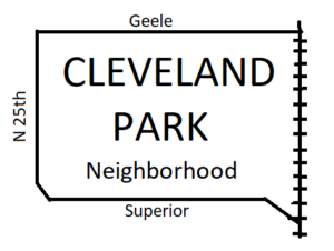
Cleveland Park Neighborhood: “Quiet Amongst the Busy”
The boundaries of the Cleveland Park Neighborhood are the east side of N. 25th Street, the north side of Superior Avenue, the west side of the railroad right-of-way that runs north to south to the east of N. 18th Street, and the south side of Geele Avenue.
The Cleveland Park Neighborhood was recognized by the Common Council as the 15th official Neighborhood Association on July 15, 2024.
Click here for a map of the neighborhood
See calendar for meeting dates and events
Neighborhood contact:
Dustin Soerens, President
sheboygancp@gmail.com

